The Genealogist’s Internet
The Genealogist’s Internet |
Maps and gazetteers are essential reference tools for family historians, and while the internet cannot offer the wealth of material available in reference libraries and record offices, let alone the British Library Map Library (see p. 274), there are nonetheless many useful resources online. Historical maps are quite rare, and the web has proved an ideal medium for making them much more readily accessible, with the result that family historians are now able to make more use of them.
Good starting points for online maps and gazetteers are the ‘Maps & Geography’ page on Cyndi’s List <www.cyndislist.com/maps/> and the Genuki county pages.
While your more recent ancestors perhaps all came from places you are familiar with, the more lines you follow the more likely you are to come across somewhere you’ve never heard of or don’t know the location of. Although your local library will have some suitable gazetteers to help you locate them, you will almost certainly find that online sources offer a much wider range of information and are, of course, much more readily to hand. Historical gazetteers are useful sources of information about these places in previous centuries.
The Gazetteer of British Place Names at <www.gazetteer.co.uk> includes 50,000 names, and provides details about the present-day administrative divisions a place belongs in, but also gives the historical county. It includes ‘commonly accepted spelling variations of place-names including an exhaustive coverage of Welsh and Gaelic spellings’. It gives OS grid references but, unlike many online gazetteers, does not link to online maps.
The National Gazetteer of Wales at <homepage.ntlworld.com/geogdata/ngw/> is a similar site, covering around 6,000 Welsh places, with Welsh and English names.
Although created for a very different purpose, Archaeology UK’s UK Placename Finder at <www.digital-documents.co.uk/archi/placename.htm> may be useful. It includes around 160,000 places and provides a sophisticated search facility. Search results show counties and grid references with a link to two general mapping sites discussed below, Bing Maps and Streetmap.
The most comprehensive gazetteer of the UK is that of the Ordnance Survey, which claims to have 250,000 place-names. However, it is of limited usefulness — it will locate a place on the Ordnance Survey map, but provides no further information. There are no obvious links to it from the OS home page at <www.ordnancesurvey.co.uk>, but it will be found at <www.ordnancesurvey.co.uk/oswebsite/freefun/didyouknow/>. Its only real advantage is that it has a very broad concept of ‘place’ and covers not only towns and villages, but even many individual farms and named geographical features.
Wikipedia can also be used as a gazetteer, though it is impossible to tell how many places are covered. Any article on a UK place includes a grid reference which links to a Geohack page with links to online maps for the place in question on all the main mapping sites including Google Maps, the Ordnance Survey and A Vision of Britain (see below).
Of course, a significant problem for the family historian in using present-day gazetteers is that the information they give may not be appropriate for earlier historical periods. In particular, the county name given for a place will be its modern administrative county, and for places now in a unitary authority or a post-1974 county a modern gazetteer will not even indicate which county a place used to be in. For this reason historical gazetteers are an essential online resource. But more than that, many historical gazetteers provide contemporary descriptions, which can be helpful in understanding the places where your ancestors lived.
The most important historical gazetteer for England, Wales and Scotland is A Vision of Britain through Time at <www.visionofbritain.org.uk>, which describes itself as ‘A vision of Britain between 1801 and 2001. Including maps, statistical trends and historical descriptions’. The site provides many different types of material — descriptive, statistical, graphical — and will take some time to explore, but the starting point is the ‘Find a place’ search. Figure 15-1 shows a typical page for a place (Tickhill, Yorkshire).
Gazetteer entries are drawn from three Victorian descriptive gazetteers:
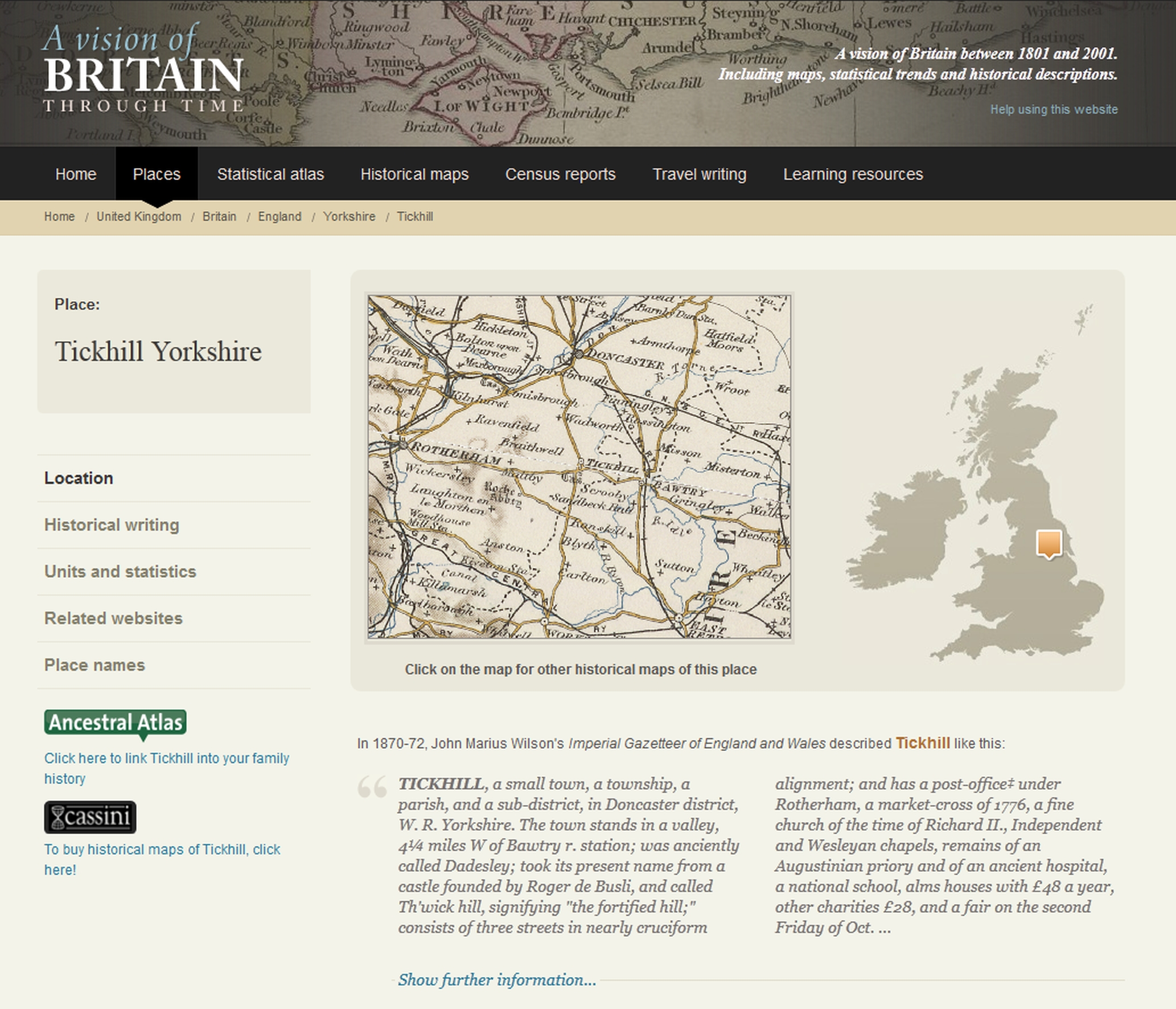
Figure 15-1: A Vision of Britain
The Bartholomew descriptions are fairly concise (particularly for smaller places), while Wilson’s are more extensive. Note that the Bartholomew gazetteer includes the present-day Republic of Ireland. To access the entries from these, you need to go to the Descriptive gazetteer search at <www.visionofbritain.org.uk/descriptions/> (or via the ‘Expert search’ link on the home page). The ‘Travel writing’ area comprises the complete texts of many important works of travel literature, mainly from the eighteenth century, but including some earlier works.
The ‘Units and statistics’ link leads to a page listing the various administrative units the place has been part of and the available statistics for each of them. For an individual village, for example, it will tell you not only which county it is (or rather was) in, but the Poor Law or Registration District, any ancient hundred it was part of, and the like. This is useful for identifying which records may have information on a place. For the genealogist, the most useful of these units will probably be the ‘civil parish and ancient parish’ and information about it will be found by following the ‘AP/CP’ link on the ‘Units and statistics’ page. The parish pages have links to population and other statistics derived from the cenuses, a map showing the parish boundaries, historical descriptions and other information. The site’s historical maps are discussed later in this chapter.
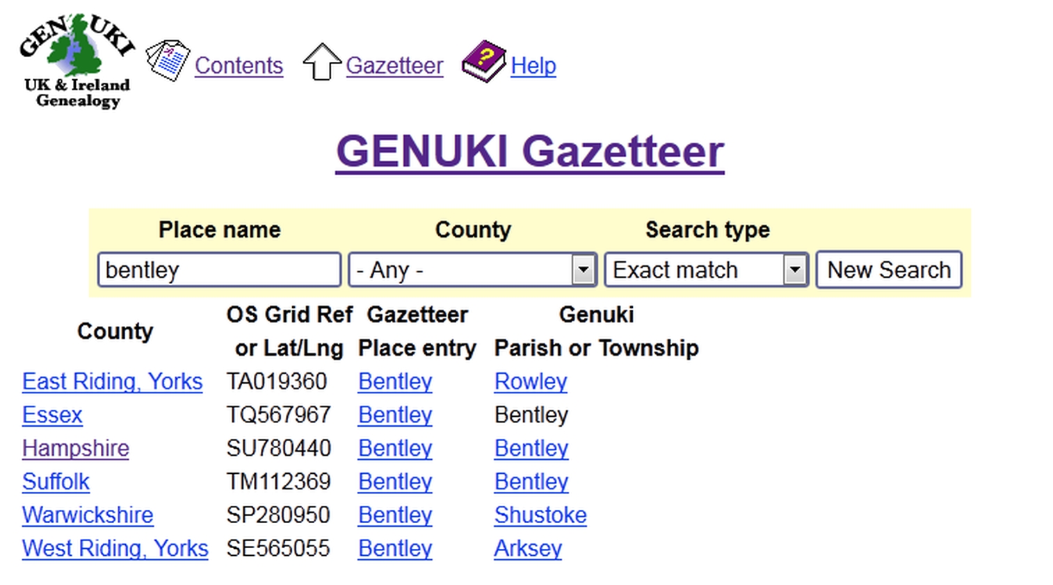
Genuki has a number of historical gazetteers which are useful for family history. The main Genuki Gazetteer at <www.genuki.org.uk/gazetteer/> is intended in the first instance to make it easier to locate the appropriate page on Genuki for information about a particular place. It includes the locations of nearly all the civil parishes at the time of the start of civil registration in 1837 (which form the basis of Genuki’s town and parish pages), but smaller places are gradually being added and for some counties coverage is very comprehensive, e.g. Cornwall with over 13,000 places. You can either view the locations of matching places on a Google map or as a list (see Figure 15-2). From the latter, you can go to a fuller gazetteer entry or the relevant Genuki parish or township page.
Figure 15-2: The Genuki Gazetteer: results for ‘Bentley’
The Genuki Church Database at <www.genuki.org.uk/churchdb/> (see Figure 15-3) provides the locations of all churches within a given distance of a particular place (the default is three miles). Results link to the Genuki parish page, if there is one.
Genuki also has a searchable database of places in the 1891 census at <www.genuki.org.uk/big/census_place.html> (covering England, Wales and the Isle of Man only). The results give the county, district and sub-district, as well as the piece number and the LDS microfilm number. There is a limited wildcard facility, in that you can truncate a name to as little as the first four letters. If you type in the name of a district or sub-district, you get a list of all the places it comprises, with their piece numbers.
Another useful tool is Darren Wheatley’s Parish Finder at <www.parishfinder.co.uk>. This allows you not only to search for the county and grid reference for any parish, but you can also search for neighbouring parishes and discover the distances between parishes.
In addition to the descriptive gazetters at A Vision of Britain, the online book archives discussed in Chapter 12 have digitized copies of many similar works. The following are just some of those worth searching for:
Note that many of these works are in several volumes, digitized individually.
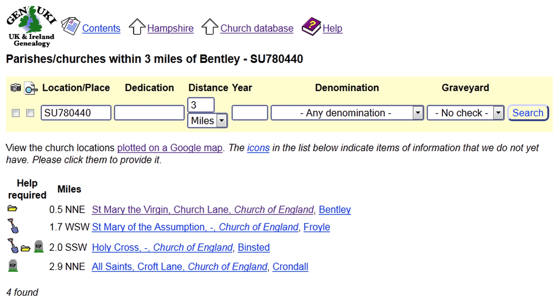
Figure 15-3: The Genuki Church Database: Bentley, Hampshire
While Scotland is included in A Vision of Britain and Genuki, there is also a major project for a specifically Scottish gazetteer based at the University of Edinburgh and accessible at <www.scottish-places.info>, the Gazetteer for Scotland. This is described as ‘vast geographical encyclopaedia, featuring details of towns, villages, bens and glens from the Scottish Borders to the Northern Isles’. Although there is a ‘Places’ search, this cannot actually be used to find towns and villages. Instead you need to use the ‘Any Word’ search at <www.scottish-places.info/anyword.html>, and select parishes and settlements. This takes you to a brief descriptive entry for the place with details of location, and a link to a very schematic county map. For a parish, it indicates all the settlements within the parish, each of which has its own description. Alternatively you can browse using the map by following the ‘Maps and Places’ link on the home page. The site includes many entries from Groome’s Ordnance Gazetteer of Scotland (1882–85) — a ‘quill and parchment’ icon on a place entry indicates a link to an extract.
The second edition of Groome’s six-volume A Gazetteer of Scotland, published in 1896, is also available in two digitizations, one at <www.gazetteerofscotland.org.uk> with a place-name search to locate a particular entry, and another on Electric Scotland at <www.electricscotland.com/history/gazetteer/> with a browsable index.
The Statistical Accounts of Scotland, which provide extensive descriptions of Scottish settlements are discussed on p. 279.
For Ireland, there are a number of online sources to help you locate historical places. The National Archives of Ireland has an OS Parish List Index at <www.nationalarchives.ie/search/index.php?category=17&subcategory=145> (or go to the Finding Aids page at <www.nationalarchives.ie/search/databases.html> and follow the Ordnance Survey link). The Irish Ancestors site has a place-name search at <www.johngrenham.com/places/>. The IreAtlas at <thecore.com/seanruad/> is a database of all Irish townlands, with details of the county and civil parish.
The Public Record Office of Northern Ireland has a ‘Geographical Index of Northern Ireland’ at <www.nidirect.gov.uk/articles/geographical-index>, which lists counties, baronies, poor law unions, dioceses, parishes and townlands in the six counties. The index is only browsable, not searchable, but there are several different routes through the material to help you find a specific place. However, I couldn’t find any way of getting a single listing of all the places with a particular name, apart from an alphabetical list of parishes at <www.nidirect.gov.uk/articles/parishes-northern-ireland>.
The Placenames Database of Ireland <www.logainm.ie> gives both the Irish and English names of a place, along with the co-ordinates and the administrative units into which a place falls. For larger places, street names are included, and the database also covers topographical features such as islands and valleys. Co-ordinates use the the Irish National Grid, which is explained briefly on Wikipedia’s ‘Irish national grid reference system’ article, and this page has links to more detailed information.
Library Ireland has a transcription of Samuel Lewis’s 1837 Topographical Dictionary of Ireland at <www.libraryireland.com/topog/> and the full work is available free of charge as a PDF file from the Ordnance Survey of Ireland online shop at <shop.osi.ie/Shop/pdf/LewisTopographicalDir.pdf>. The Irish Place Names database at <www.irish-place-names.com> is based on the Index to the Townlands, and Towns, Parishes and Baronies of Ireland published in 1861 after the census of Ireland carried out in 1851. This database lists all of the villages, towns and townlands that were enumerated, as well as the Barony, Civil Parish and Poor Law Union that each was located in.
With the exception of the ‘Geographical Index of Northern Ireland’, all these resources cover the whole island of Ireland.
As well as these national gazetteers, there are many resources for counties and larger towns. It is not possible here to give a comprehensive listing — the easiest way to find them is to go to the Genuki page for the relevant county at <www.genuki.org.uk/big/>. There are also many small-scale scans and transcriptions for individual places of material from historical gazetteers. The Genuki page for a county or for a particular town or village will normally start with a brief description taken from a nineteenth-century source. Trade directories, discussed on p. 189, will also give the location of a place and other information. For London, see p. 269.
All towns and villages in the British Isles have a place in the administrative geography of the constituent counties, and this has not necessarily remained constant over the last few hundred years. A number of the gazetteers already mentioned include information on the administrative units to which towns and villages belong, most notably A Vision of Britain (p. 254). But there are also some resources specifically devoted to this issue, which is important for family historians because it has a bearing on where records are likely to be found.
Genuki provides a general overview of Administrative Regions and, as well as pages for the individual counties, has material on ‘Local Government Changes in the United Kingdom’ at <www.genuki.org.uk/big/Regions/UKchanges.html> with detailed tables for England, Wales, Scotland and Northern Ireland. The situation in the Republic of Ireland is more straightforward as the pre-independence counties remain. The Gazetteer of British Place Names, mentioned above, has maps of the old counties as well as the new counties and unitary authorities at <www.gazetteer.co.uk>. It is also well worth looking at their ‘Additional notes for historians and genealogists’ at <www.gazetteer.co.uk/section4.htm>, which explains the difference between the historic counties, the ‘registration counties’ used by the GRO, and the nineteenth- and twentieth-century administrative counties and county boroughs.
If you are from outside the UK and are not familiar with the counties and other administrative divisions you will find Jim Fisher’s page ‘British Counties, Parishes, etc. for Genealogists’ at <www.jimella.me.uk/counties.cfm> useful.
Where counties have changed their boundaries over the years, the individual Genuki county pages will provide relevant details. The complex set of changes which, in less than a hundred years, saw parts of the home counties, and indeed the whole of Middlesex, incorporated into the capital are dealt with on the Genuki London site at <www.genuki.org.uk/big/eng/LND/parishes>. Genealogists almost always refer to pre-1974 counties and any genealogical material on the internet is likely to reflect that. This is why there are no pages on Genuki for Tyne and Wear or the present-day divisions of Wales. But non-genealogical sites will tend to locate places in their current counties, even if the material is from the nineteenth century — a number of the sites with photographs discussed in Chapter 17 do this, for example.
The traditional pre-1974 counties are often referred to by three-letter abbreviations, usually referred to by genealogists as the Chapman County Codes, e.g. SFK for Suffolk. A list of these can be found on Genuki at <www.genuki.org.uk/big/Regions/Codes.html>. There is a brief account by Colin Chapman of the origin of the codes at <www.lochinpublishing.org.uk/about>.
Gazetteers may be even more important if you have ancestors who migrated. It is not possible here to cover individual countries outside the British Isles, but there are a number of places to look. As you would expect, Cyndi’s List has links to many online gazetteers. They are included in the ‘Maps & Geography » General Resources’ page at <www.cyndislist.com/maps/general/> under two distinct headings: ‘Historical Maps, Atlases & Gazetteers’ and ‘National Gazetteers & Geographic Information’, of which the latter has the most useful entries.
The most comprehensive world gazetteer is the Getty Thesaurus of Geographic Names Online at <www.getty.edu/research/tools/vocabularies/tgn/>. Even for the UK this is useful, since it includes geographical, and some historical, information. However, it is not intended to be comprehensive, and concentrates on larger places. For example, it gives only one place in Ireland called Inch, while the Irish Ancestors site (see p. 258) lists a dozen.
The Imperial Gazetteer of India is discussed on p. 178.
If these resources fail to find your place, it is worth checking Wikipedia at <en.wikipedia.org>, which has many articles on individual places all over the world, and not just the major towns and cities. Otherwise, see whether there is a mailing list devoted to the country you are interested in — listed at <www.rootsweb.ancestry.com/~jfuller/gen_mail.html> — and post a query. There will almost certainly be people on the list with suitable reference works to hand or even local knowledge.
The OS website at <www.ordnancesurvey.co.uk> is the obvious starting point for any information about present-day mapping of the British Isles. This provides a facility called Get-a-map at <www.ordnancesurvey.co.uk/oswebsite/getamap/>, which allows you to call up a map centred on a particular place. You can search by place-name, postcode, or OS grid reference. Alternatively, you can just click on the map of the UK and gradually zoom in to your chosen area. The maps are free for personal use (including limited use on personal websites). The standard OS one-inch map is available, but there is also a ‘ZoomMap’ which shows more detail (individual houses), and is shown in Figure 15-4. Get-a-map requires you to install Microsoft Silverlight for your browser. You can print half-page maps free of charge but you cannot download maps as graphics except by doing a screenshot.
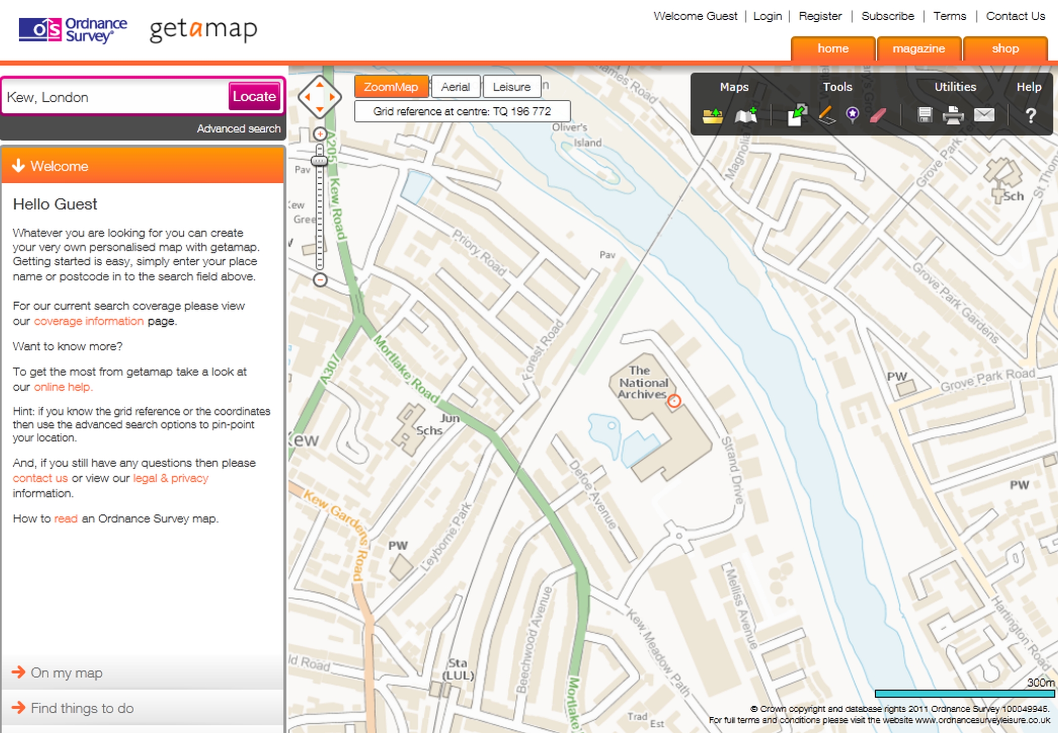
Figure 15-4: The National Archives in Get-a-map
A relatively unknown source of OS maps for England is the MAGIC (Multi-Agency Geographic Information for the Countryside) site at <magic.defra.gov.uk>, shown in Figure 15-5. The site is designed to provide information for countryside management, shown in a number of layers, over a base map, which is a monochrome modern OS map. MAGIC has a number of advantages over the Get-a-map service, though because this site is designed for specialist use, it is more complex to use than those designed for the general public. To access the maps, from the home page you need to choose Interactive Map, then choose Administrative Areas from the top field, and enter a place, postcode, or grid reference in the lower. There are many options once you are viewing a map. A Map Tools tab gives access to a range of tools, including the ability to identify an area, and to save a map as a GIF file. You can also bookmark the current view. Another useful feature of MAGIC is that it shows modern civil parish boundaries.
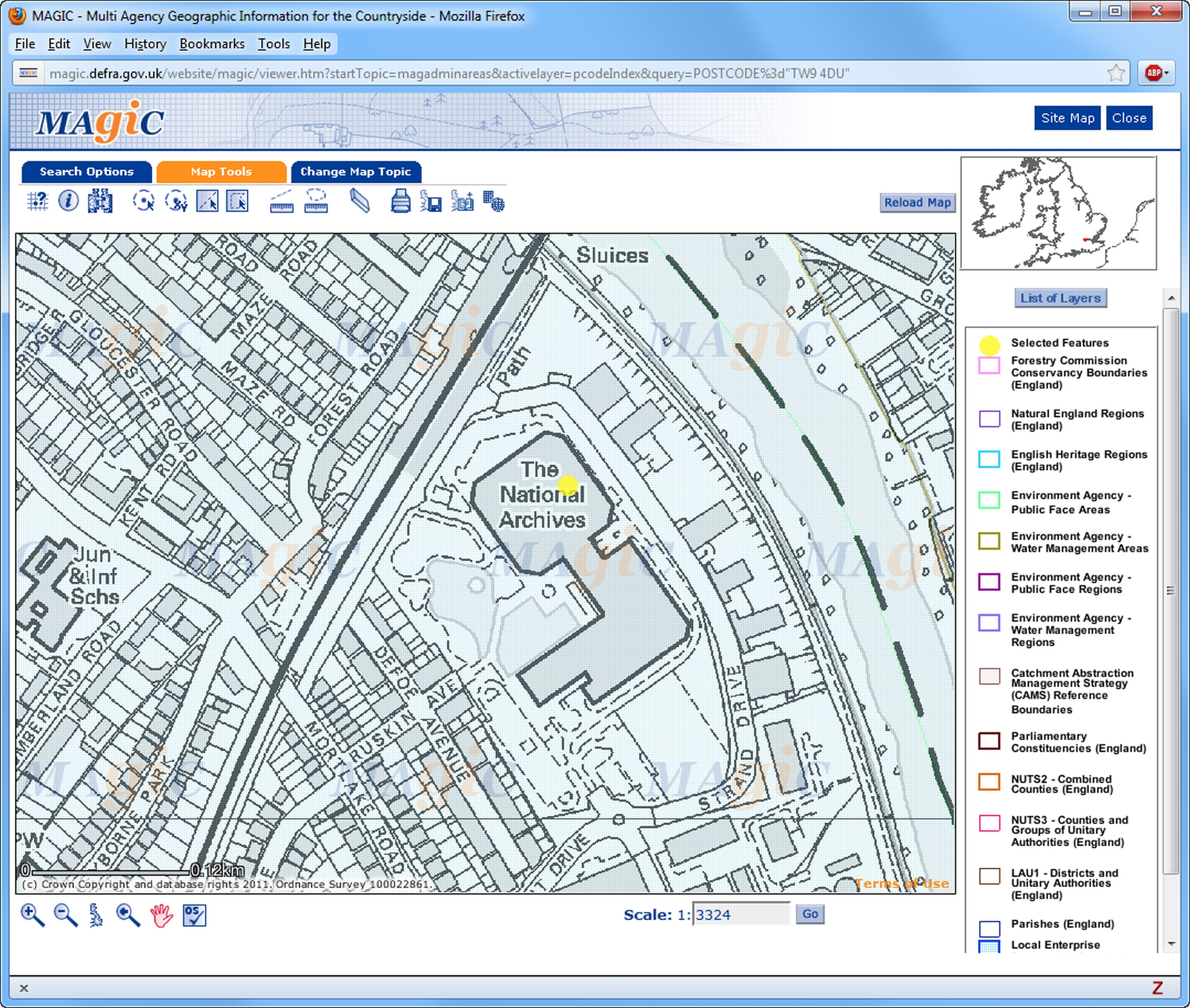
Figure 15-5: The National Archives in MAGIC
There are five main sites that provide free UK street maps. Streetmap at <www.streetmap.co.uk> allows searches by street, postcode, place-name, OS grid, Landranger grid, latitude/longitude or telephone code. Bing maps at <www.bing.com/maps/> offers similar facilities: the initial search option offers place or postcode, while the advanced search includes building and street. Google Maps at <maps.google.co.uk> shows only streets, and doesn’t indicate even quite major landmarks (e.g. Canterbury Cathedral, Stonehenge). OpenStreetMap at <www.openstreetmap.org> is a non-commercial collaborative street mapping site, which includes not only street names, but also the names and locations of buildings like churches and pubs.
Genuki has instructions at <www.genuki.org.uk/big/ModernLocations.html> on ‘How to find a present day house, street or place in the U.K. (or to find only the Post Code)’ by using the Royal Mail site on Streetmap, Bing maps or Google Maps.
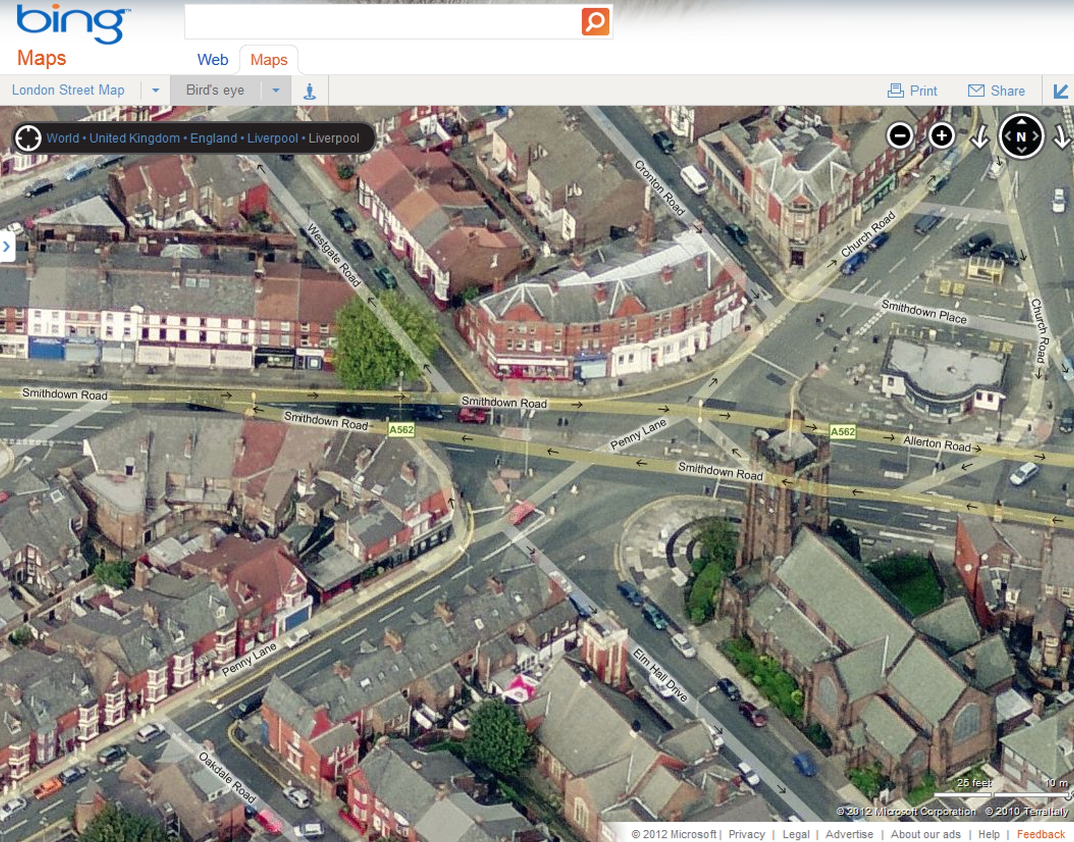
Figure 15-6: Bing Maps: Bird’s Eye view of Penny Lane, Liverpool
For aerial photographs, there are two main options. Bing provides photographs which, for the most populous parts of the country, are at a high level of detail. The site has an aerial view and a ‘Bird’s Eye’ view (see Figure 15-6), which allows you to see the façades of individual buildings. Both are on the ‘Bird’s eye’ menu. Google Maps has a satellite mapping option covering the whole country (and indeed the whole world), though resolution varies from area to area. There are various levels of zoom, options to rotate and tilt the images, and very quick panning. The same images can be viewed in Google Earth, a free downloadable viewer for satellite maps at <earth.google.com>. This has the advantage of an overlay showing roads and street names. It also offers a ‘placemark’ facility so that you can keep a permanent marker for places you want to view again. Because of the amount of data transferred, Google Earth requires a broadband connection and a fairly recent Windows PC. With an older machine you will need to check whether your graphics card is supported before downloading.
Historical Aerial Photography at <www.oldaerialphotos.com> is a commercial site offering aerial photographs for sale. Unfortunately, the site does not offer any preview — you have to select the location you want using the OS one-inch map. Photographs are supplied either as prints or as digital images on CD in TIFF format. A similar service is offered by UK Aerial Photos at <www.ukaerialphotos.com>, which includes aerial photos from the 1940s as well as from recent years. The photographs are JPEG images, which are sent by email. This site does offer a preview of the photo.
The old Ordnance Survey maps are among the most useful for the family and local historian. Covering the whole country at a standard set of scales over a period of 170-odd years, with few exceptions they are the only maps which show, at the largest scale, every plot of land and every individual building.
A Vision of Britain is the best site for the old one-inch OS maps for England, Wales and Scotland. It has a full set of high quality scans covering the period up to 1948 from the Historical Maps page at <www.visionofbritain.org.uk/maps/>. Unfortunately you cannot really download a whole map as the screen display is made up of numerous individual tiles, so the only way to have your own copy is to do a screenshot. The site also has two sets of Boundary Commision maps, based on the OS map, covering each county and the London metropolitan boroughs.
British History Online (p. 279) has one-inch maps for the whole of Great Britain and six-inch maps for around 20 major cities at <www.british-history.ac.uk/catalogue/maps>, which can be searched by place-name or postcode. Unfortunately the 25-inch OS maps of England and Wales do not seem to be publicly available online, though Higher Education users have access to them on the EDINA Digimap site at <edina.ac.uk/digimap/>.
But for Scotland, the National Library of Scotland has a comprehensive collection of OS maps online at <maps.nls.uk/os/>, including the 1st edition 25-inch maps, dating from 1855–1882. The site also has the Ordnance Survey town plans for 61 Scottish towns, made at the astonishing scales of 5 and 10 feet to the mile and dating from 1847–1895 with an extraordinary level of detail. Rather surprisingly, the site also has the one-inch maps for England and Wales, not linked from the OS map page mentioned, but accessible from <maps.nls.uk/os/oneinch_new_popular_list.html>.
Another site with nineteenth-century Ordnance Survey maps is the London Ancestor’s collection of maps from the report of the 1885 Boundary Commission, which includes Ireland. There are maps for individual counties, and for the inner London boroughs. All are linked from the Old London Maps page at <www.londonancestor.com/maps/maps.htm> — the links for other areas are at the foot of the page. For Wales and Scotland, only a selection of counties and towns is included. For Ireland, it has these maps for 26 of the counties at <www.londonancestor.com/maps/maps-ireland.htm>. These are at a smaller scale of four inches to the mile but show barony and constituency boundaries.
Ordnance Survey Ireland at <www.osi.ie> has probably the most useful collection of Irish OS maps: alongside modern maps for the Republic, the nineteenth-century six-inch and 25-inch maps for the whole of Ireland are available at <maps.osi.ie> (the six-inch maps are provided in both greyscale and colour). You can only download maps via the online shop, though of course you can take a screenshot.
Ask About Ireland’s Griffiths Valuation index at <www.askaboutireland.ie/griffith-valuation/> (see p. 123) links index entries with contemporary OS map sheets. Unfortunately you can only see the map after entering a surname search, but if you enter a common Irish surname (Murphy, Kelly) and select a county, you can then navigate the map to find the right area. There is a slider at the top right of the map window which you can use to fade between the modern map and the historical map, making it fairly straightforward to find a place. You need to zoom in quite considerably to see any detail.
A long-standing commercial site for historical maps is Old-maps at <www.old-maps.co.uk>, which has scans of the First Series of six-inch OS maps of England, Wales and Scotland available for purchase, with a free preview. The initial place-name search brings up a modern map and you need to select a historical map from the scrolling list on the right of the window. This is too small to see any but the most obvious geographical detail, but clicking on ‘Enhanced Zoom’ brings a higher resolution image with a zoom button, which will allow you to blow up text and finer details.
Scotland is particularly well served by historical map digitization projects. and there are two outstanding sites for maps of the country.
The National Library of Scotland, which has already been mentioned as a source of OS maps, has over 27,000 maps in its Digital Library at <www.nls.uk/maps/>. Among the others on the site are:
The quality of the scans is excellent.
The other major site is Charting the Nation at <www.chartingthenation.lib.ed.ac.uk>, which is run by the University of Edinburgh Library and has maps for the period 1550—1740. (In fact, there are some later maps, as the site includes The Board of Ordnance collection of military maps and architectural plans dating from around 1690 to about 1820.) While some of the maps are at too small a scale to be of any genealogical utility, there are others which are detailed enough to show individual streets and buildings. Unlike most map sites, rather than selecting a map and then having to load a map viewer, here you start the map viewer first and then select which map you want to look at. There are two different viewers, the second and more sophisticated of which requires the download and installation of a plug-in. The basic viewer can be slightly confusing at first, as it uses several different windows. It also requires your browser to have any pop-up blocker disabled — consult your browser’s online help to find out how to do this.
Maps of the Scottish clans are discussed on p. 244.
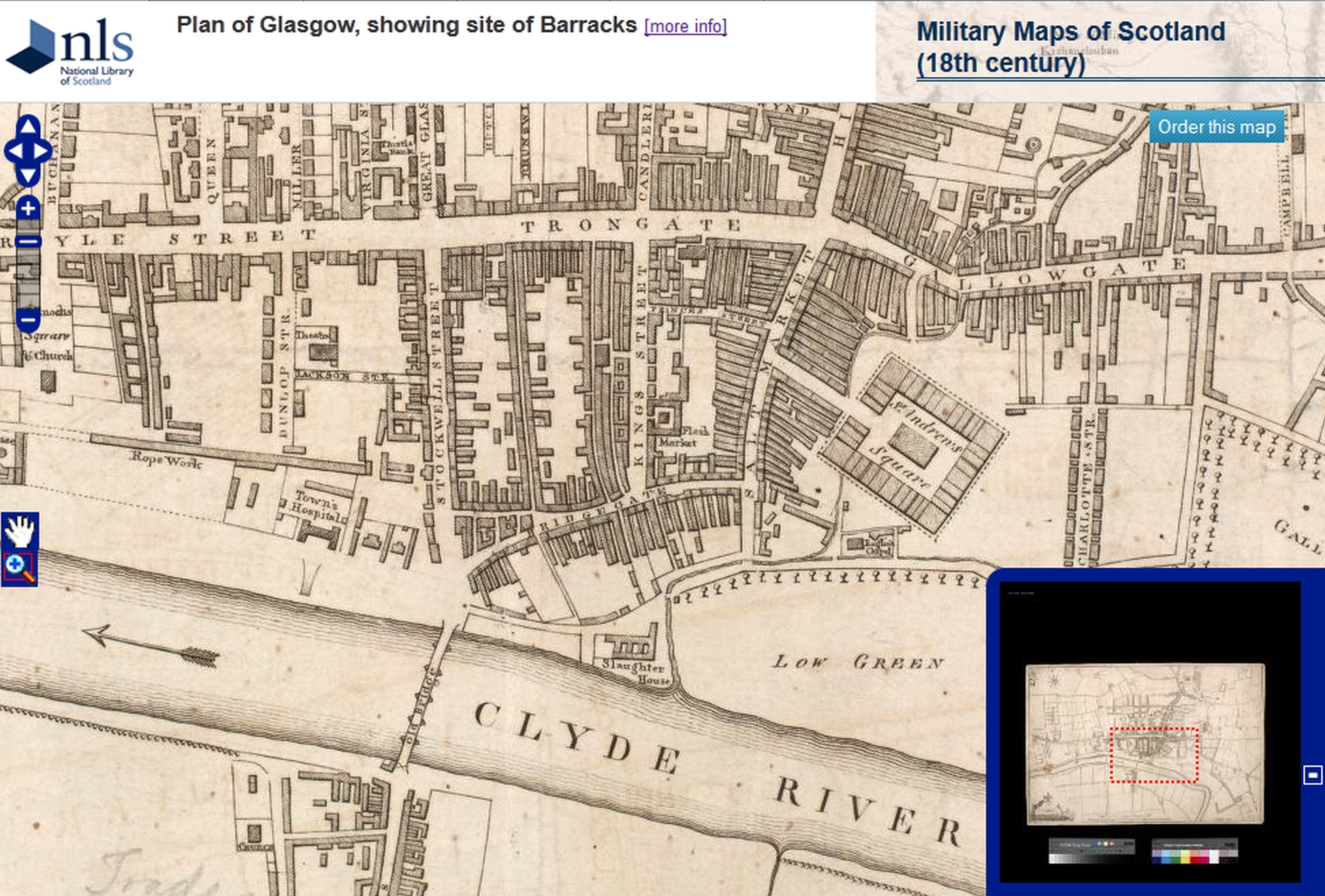
Figure 15-7: An eighteenth-century map of Glasgow (NLS)
There are plenty of other maps of Ireland online, though the OS maps are probably by the most generally useful. Among the other offerings on the web, the University of Wisconsin-Madison has a Poor Law map, at <history.wisc.edu/archdeacon/famine/map.html>, University College, Cork has a collection of Irish county maps at <www.ucc.ie/celt/mapsireland.html>, taken from an 1881 atlas, and the Perry-Castañeda Library has a 1610 town plan of Dublin at <www.lib.utexas.edu/maps/historical/dublin_1610_1896.jpg>.
Irish Townland Maps at <www.pasthomes.com> is a commercial site offering maps of Irish townlands from the 1830s. An annual subscription costs $25, which allows you to browse the site, and you can then purchase maps at two different resolutions. Maps are provided in PDF format, and two sample maps show the size and resolution available.
Many institutions and individuals have scanned classic historical maps and map editions. Those covering whole countries tend not to be very useful for genealogists because of their small scale, but this is not the case for maps of individual counties and towns.
The most extensive volunteer-run site is Genmaps at <freepages.genealogy.rootsweb.ancestry.com/~genmaps/>, which covers England, Wales and Scotland, with an enormous collection of maps for the counties, as well as many for individual towns and cities. The site doesn’t give a figure for the total number of maps available, but it must be a couple of thousand — there are 200 just for Yorkshire, and even Rutland is represented by 40 maps. Genmaps also has an extensive collection of links to other historical map sites, including those of several dozen commercial map dealers, many of whom have low-resolution scans on their sites.
Other projects devoted to individual map collections include Tom Arnold’s scans of Samuel Lewis’ county maps of Wales and Ireland dating from around 1840. These are linked from <homepage.ntlworld.com/tomals/index2.htm>. John Speed’s early seventeenth-century maps of around 30 English towns and cities (plus Edinburgh) have been digitized by Professor Maryanne Horowitz of Occidental College, Los Angeles, and are available at <faculty.oxy.edu/horowitz/home/johnspeed/>. The proof versions of Speed’s county maps have recently been digitized by Cambridge University Library and posted online at <www.lib.cam.ac.uk/collections/departments/maps/digital-maps/john-speed-proof-maps>. Maproom.org has maps from Cary’s Traveller’s Companion of 1790, showing main roads and distances, at very high resolution, at <www.maproom.org/00/07/>. There are also maps from some more modern printed works which are likely to be of interest. For example, Alan Gresley has scanned the town plans from the 1910 edition of Baedeker’s Great Britain Handbook for Travelers at <contueor.com/baedeker/great_britain/>
Mapseeker is a commercial site with a collection of historical maps under the heading ‘Genealogy Map Resources’ at <www.mapseeker.co.uk/genealogy/>. Particularly useful are the city maps for Birmingham, Edinburgh, Liverpool and Manchester. There are good-quality scans of a section of maps viewable free of charge, and many more are available for purchase.
There is no online map collection from the British Library, though the BL’s Images Online website at <www.imagesonline.bl.uk> includes some digitized maps. These can be found by selecting the ‘Maps and Landscapes’ link from the Subject Index. The scans are only intended to enable you to make a purchase and are not high enough resolution to use in their own right. There is also an extensive range of supporting material on maps in the ‘Help for researchers’ area of the site at <www.bl.uk/reshelp/findhelprestype/maps/>, including articles on the various series of Ordnance Survey maps, useful background to some of the sites mentioned above.
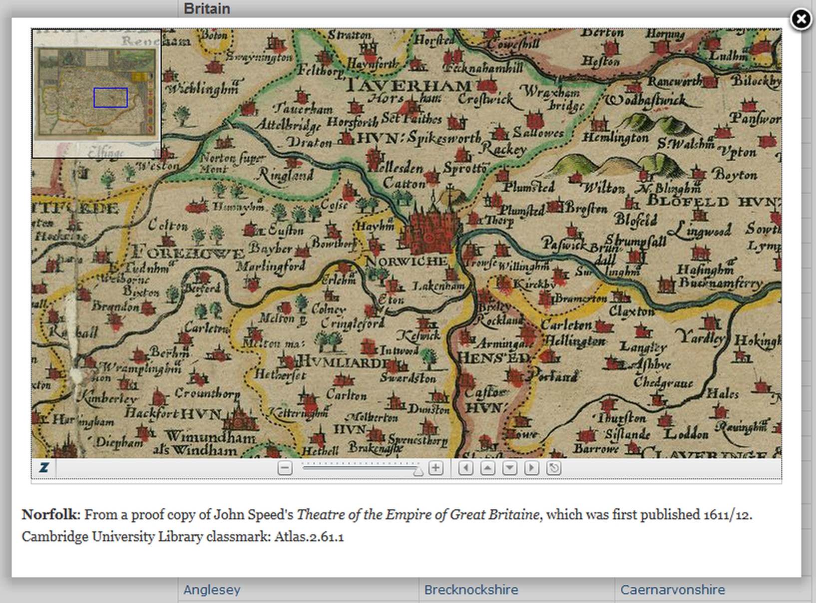
Figure 15-8: Detail of John Speed’s map of Norfolk (Cambridge University Library)
The National Library of Wales’s ‘Digital Mirror’ has maps from Thomas Taylor’s 1718 work The Principality of Wales exactly described, the first atlas of Wales, at <www.library.wales/discover-learn/digital-exhibitions/maps/county-maps/the-principality-of-wales-exactly-described>.
In addition to the sections for individual counties on Genmaps, there are many sites with map collections for individual counties and towns.
The University of Portsmouth’s Geography department hosts two county collections, each with a very comprehensive range of historical county maps going back to the sixteenth century:
For County Durham, Pictures in Print at <valentine.dur.ac.uk/pip/> is a collaborative project between the British Library and the various holders of map archives in Durham to produce an online catalogue for the maps of the county along with digital images. To view the images, you will need to download a plug-in (it downloads automatically for Internet Explorer, but may need to be manually installed for other browsers). There are several different search categories, of which the place search is likely to be the most useful. The subject search is also useful, though it is better to select from the list of subject index terms rather than try and guess the subject headings.
Lancashire has a wide selection of OS maps for the county at a variety of scales at <www.lancashire.gov.uk/shared-components/redirects/mario/mario-map-gallery/>, covering the period from the First Series up to the 1950s, along with some older county maps.
A particularly good site is Cheshire’s E-mapping Victorian Cheshire at <maps.cheshireeast.gov.uk/tithemaps/>, which allows you to compare a nineteenth-century map of an area (including the 1840s tithe maps) with a modern map. Figure 15-9 shows Tranmere in the tithe and modern maps. (Since tithe maps are primary sources for genealogists they are discussed in more detail in Chapter 8 on p. 120.)
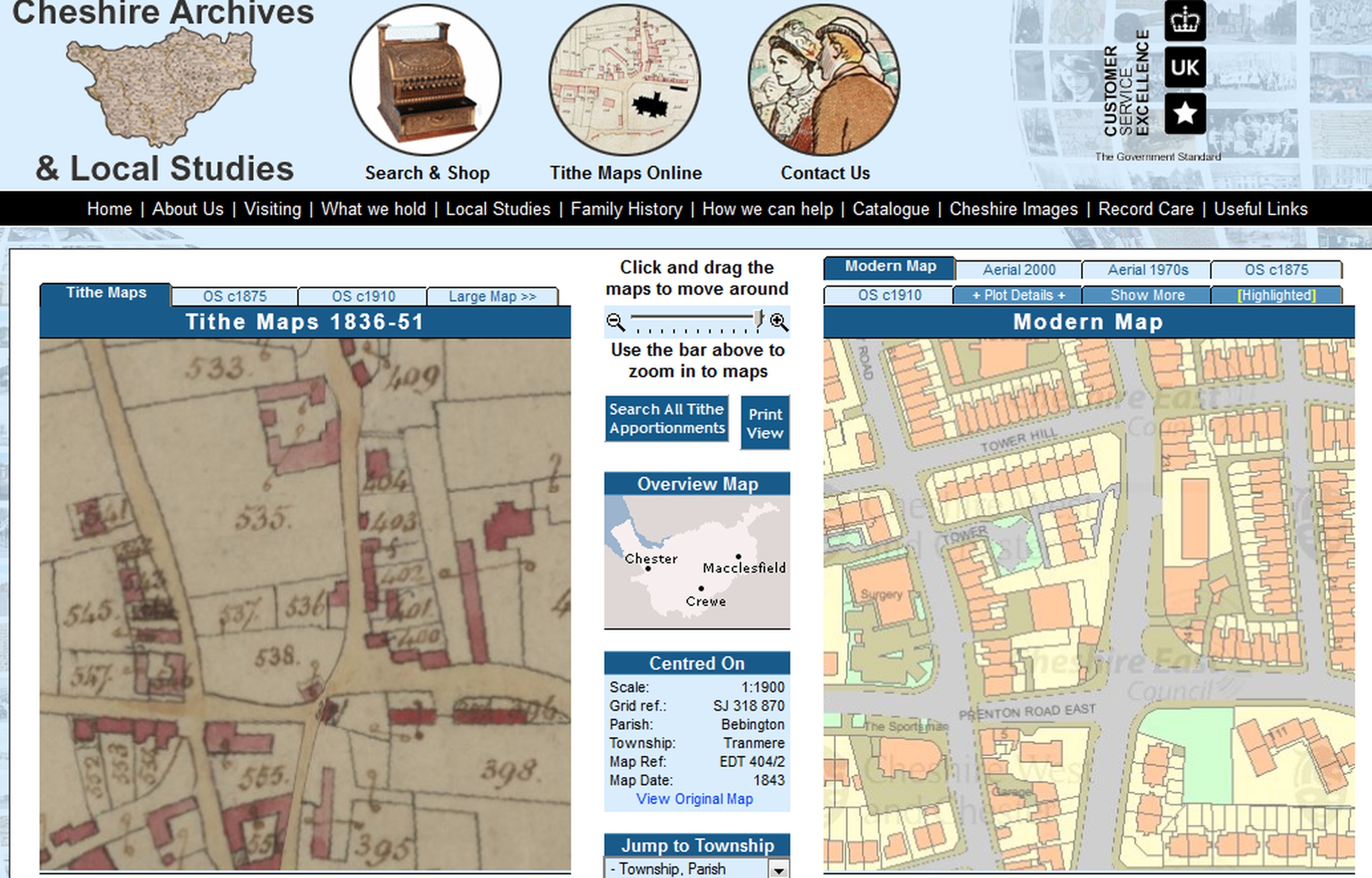
Figure 15-9: E-mapping Victorian Cheshire
There is an enormous wealth of online maps for London, many of which show the names of individual streets. Genmaps has scans of over 170 historical maps, plans and panoramas of London at <freepages.genealogy.rootsweb.ancestry.com/~genmaps/genfiles/COU_Pages/ENG_pages/lon.htm> from the 1560s to 1920, including John Roque’s detailed 24-sheet map of 1746 and many plans of City wards. The site also has many county maps for Middlesex, though these are mostly not at the same level of detail.
Another site with a range of important and useful maps is MOTCO, with historical maps and panoramas of London from 1705 onwards at <www.motco.com/map/>. Some maps have place indexes — for example Stanford’s 1862 Library Map of London and its Suburbs has an index to around 5,000 streets, with a link to the relevant portion of the map. MAPCO has a number of the most detailed maps of the capital at <mapco.net/london.htm>, many at exceptionally high resolution.
The Collage site at <www.londonpicturearchive.org.uk> includes many maps and plans among its 20,000 or so images, mainly drawn from the Guildhall Library’s Print Room. Particularly useful is the place search, which links to plans of individual City wards and parishes. There are also many views of individual streets, as well as insurance plans showing the locations of individual buildings. High resolution digital files of the images can be purchased online.
If you are trying to find a London street mentioned in a census but which no longer appears on the A—Z, the Lost London Streets site will be worth looking at. This gives an A—Z reference with details of what happened to the street. It covers over 3,500 streets that have undergone a name change or have disappeared altogether over the last 200 years. Unfortunately the original site was closed down a few years ago, but a copy of all the pages is available on the Wayback Machine: <members.aol.com/WHall95037/london.html> (11 August 2005).
GenDocs’ Victorian London Street index will be found <homepage.ntlworld.com/hitch/gendocs/lon-str.html>. For over 61,000 streets this gives a postal district or locality and metropolitan borough, but no more precise location. For an earlier period, The London Ancestor has a street index to W. Stow’s 1722 Remarks on London: Being an Exact Survey of the Cities of London and Westminster… at <www.londonancestor.com/stow/stow-strx-all.htm>.
UCLA’s Department of Epidemiology has an area of its website at <www.ph.ucla.edu/epi/snow/snowcricketarticle.html> devoted to John Snow, one of the founders of the discipline, and this includes a number of London maps from the mid-nineteenth century. These have been scanned at very high resolution and are of exceptional quality.
One of the most famous London maps, Charles Booth’s 1889 Map of London Poverty, is available on the LSE’s Charles Booth site at <booth.lse.ac.uk>, which shows Booth’s original map against a modern one (Figure 15-10).
For a more detailed survey of the most genealogically useful maps of London and the sites where they can be found, see my article ‘London Maps Online’ at <www.spub.co.uk/articles/londonmaps.pdf>.
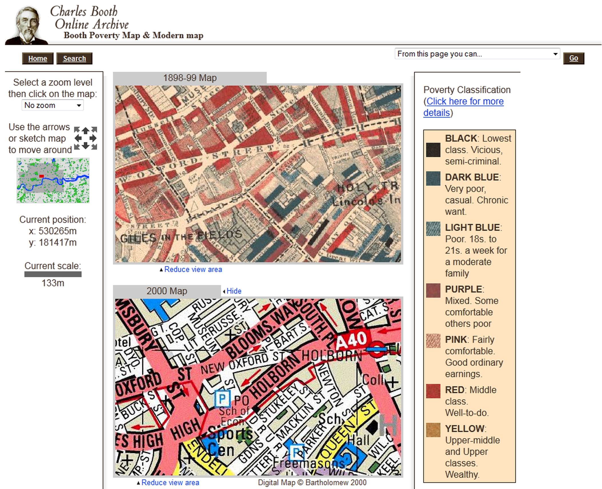
Figure 15-10: Charles Booth Online Archive, Booth Map & Modern Map
Maps of the ancient ecclesiastical parishes are among the most useful for the family historian.
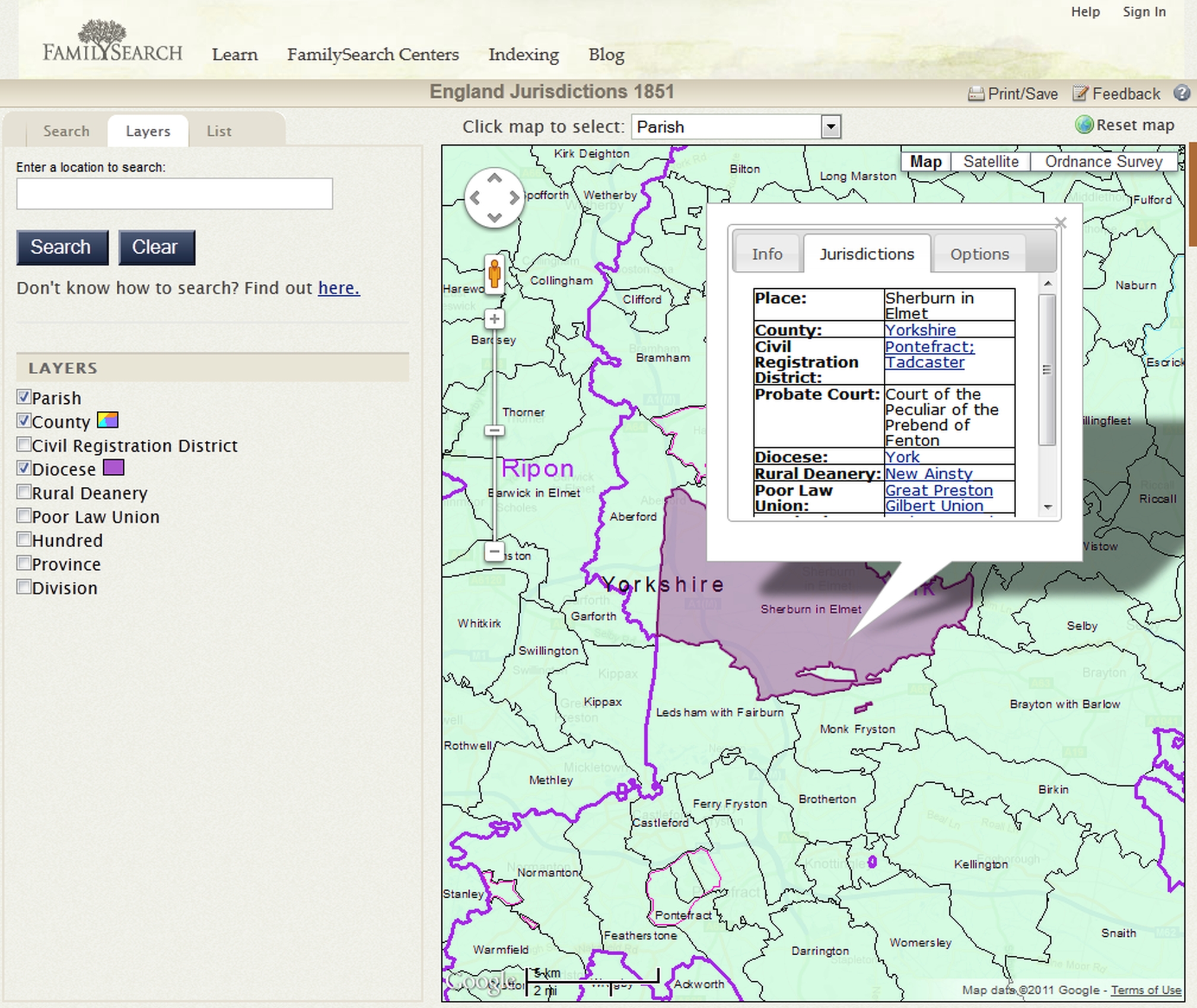
FamilySearch has a dedicated map site at <www.familysearch.org/mapp/>, which currently has a single offering: English Jurisdictions 1851. Over a base map showing the counties of England, you can select one or more layers, each of which shows the boundaries for a particular type of administrative unit — Parish, County, Civil Registration District, Diocese, Rural Deanery, Poor Law Union, Hundred, Province, Division, and Probate. The ability to select more than one layer can be very useful: you can see which diocese a parish belongs to (see Figure 15-11) or which parishes are covered by a particular registration district. The ‘Ordnance Survey’ button at the top right of the window overlays the boundaties on a nineteenth-century OS map, so that you see the boundaries against the topography. Clicking on an individual parish produces a pop-up window with information about the parish or other unit.
Figure 15-11: FamilySearch’s English jurisdictions map
For the civil parishes established in the nineteenth century, A Vision of Britain (p. 254) has a complete set of four-inch Ordnance Survey maps for England and Wales showing the Sanitary Districts and Civil Parishes. Larger-scale insets show the details of the much smaller parishes in cities and large towns. From the maps page at <www.visionofbritain.org.uk/maps/>, click on the ‘Boundary maps’ tab, then ‘Ordnance Survey Sanitary Districts, showing Civil Parishes’ and use the clickable map to zoom in on the county of interest. (See Figure 15-12.)
As mentioned in Chapter 7, the Church of England’s A Church Near You site at <www.achurchnearyou.com> shows modern parish boundaries for each parish church, which for areas that are still rural should be a good guide to older boundaries (Figure 7-1, p. 99).
If you just need to see the location of a parish relative to the surrounding area, many Genuki county pages have a map showing the parishes within the county. Also, most family history societies have a map on their website showing the location of the parishes for their area. Look at Genuki’s list of FHSs at <www.genuki.org.uk/Societies/>.
The Gazetteer of Scotland site (see p. 257) includes all the county maps — from the home page at <www.gazetteerofscotland.org.uk/scotland/ctyindex.htm> follow the link to ‘Counties and County Maps’. These maps are quite hard to read, but they have been scanned at very high resolution and the six levels of zoom should allow you to see the details for smaller areas or you can download the image. The New Statistical Accounts of Scotland (see p. 257) has a number of parish maps but the most convenient way to access these is not via the Statistical Accounts website at <stataccscot.edina.ac.uk/static/statacc/dist/exhibition/nsa>, but on Forrest Anderson’s site at <www.forrestdale.pwp.blueyonder.co.uk/Parishes.html>, where they are reproduced in good quality scans.
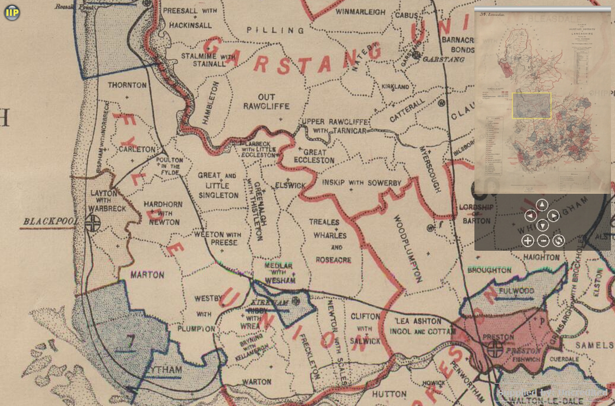
Figure 15-12: A Vision of Britain: Civil parish boundaries
Maps of Irish civil parishes, which match the Church of Ireland parishes, will be found on the Irish Ancestors site at <www.johngrenham.com/places/civil_index.php>, which has maps for the Roman Catholic parishes at <www.johngrenham.com/places/rcmap_index.php>. For Counties Roscommon and Leitrim, there is a very comprehensive set of maps showing Roman Catholic and civil parishes, as well as Poor Law unions, at <www.leitrim-roscommon.com/LR_maps.html>.
For guides to archival map collections, the British Cartographic Society’s ‘A Directory of UK Map Collections’ at <www.cartography.org.uk/ukmca> is a very comprehensive starting point. This is part of the site’s ‘Map Curators Toolbox’ [sic], which contains much useful information about maps and mapping. The Toolbox home page is <www.cartography.org.uk/the-map-curators-toolbox> (there seems to be no link to this from the BCS home page).
The catalogues of the archives and libraries mentioned in Chapter 13 include map holdings. The National Archives has a page on ‘Looking for a map’ at <www.nationalarchives.gov.uk/records/looking-for-place/maps.htm> and a research guide ‘Maps and plans research’ at <www.nationalarchives.gov.uk/help-with-your-research/research-guides/maps-further-research/>.
The national libraries all have significant map collections which are described on their websites:
Of course, there are many more maps online than it has been possible to mention here, particularly for local areas. Some of the larger sites mentioned have good collections of links, but there are two other obvious places to look for links to other online maps. First, the Genuki page for a county or parish (start from <www.genuki.org.uk/big/>) should have a range of links to relevant maps, and some of the parish pages have a map of the parish.
For older maps on a worldwide basis, probably the best starting point is the Map History gateway at <www.maphistory.info/webimages.html>, maintained by Tony Campbell, former Map Librarian of the British Library. The Europe page at <www.maphistory.info/imagebi.html> has links to over 60 sites with individual maps or map collections for the British Isles.
ABCgenealogy has a number of links to a number of maps and map collections for the UK and Ireland at <www.abcgenealogy.com/Maps/Europe/>.
For map collections with local coverage it will always be worth checking the websites of the relevant record offices, whose online catalogues are also good places to start looking for details of the maps which aren’t online.
Another source for historical maps online may be the sites of commercial map-dealers, many of whose websites have scans of the maps they have for sale. It is well worth using a search engine to locate sites which have the phrase “antique maps” and the town or county of your choice.
A new portal for locating historical maps on the web was launched in February 2012. Old Maps Online at <www.oldmapsonline.org> is a university-funded project to create a free website ‘enabling users to search for online maps across many different digital libraries, based not on the titles of maps or who drew them, but on the places the user is interested in’. The site does not host maps itself, but links to the images on sites such the British Library, the National Library of Scotland, and A Vision of Britain. The scope of the project is worldwide, but initially the British Isles and North America have the fullest coverage. For the genealogist, the most useful materials are probably the huge range of Ordnance Survey maps. A date slider allows you to focus on the maps for a selected historical period.
One upshot of the increasing range of interactive facilities online is that it is now possible to have customized maps identifying places relevant to your family tree. Google, in particular, allows web designers to take a map from Google Maps and plot particular locations on it from a data source. You can see some of the possibilities from the Genuki gazetteer (p. 256), with its ‘plot places on a map’ option.
Obviously, setting this up on a website of your own requires considerable technical knowledge, but MapYourAncestors at <www.mapyourancestors.com> is a free service which enables you to plot the locations of your ancestors’ dwellings or events in their lives on a Google map. Putting these locations in a sequence makes it possible to follow the travels or migrations revealed by records. The site is rather short on documentation, but there is an article about it by Dick Eastman at <blog.eogn.com/eastmans_online_genealogy/2007/07/map-your-ancest.html> and About.com has an article by Kimberley Powell ‘Map Adventures with Google’ at <genealogy.about.com/od/geography/a/google.htm>. Further examples of the possible uses and a brief demonstration will be found in an article I wrote for Ancestors on the subject in 2009, which is available at <www.spub.co.uk/articles/interactive-mapping.pdf>.
Next chapter: 16 History
This version of The Genealogist’s Internet by Peter Christian is licensed under CC BY-SA 4.0